
J.A. KRUG 5 15-167-23113 · Russell County needs expert review
Document 15-167-23113_ACO · 2 page(s) · read with option layout · source scan (KGS).
Click a row to highlight where it was read on the scan. Read-only (Phase 1).
 page 1
 page 2
Extracted fields & KGS master-list cross-check
| Field | Value | Confidence | Page | Snippet | Cross-check |
|---|---|---|---|---|---|
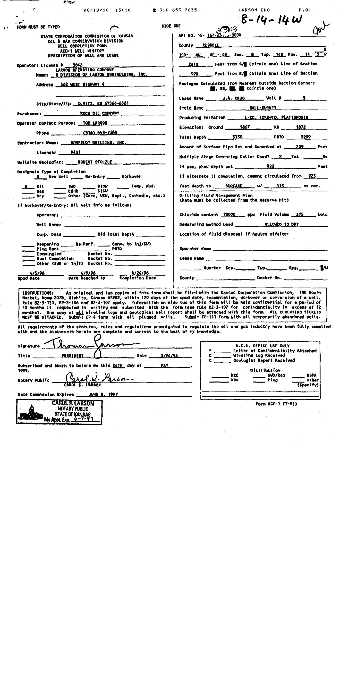
| Document type | well completion form | 1.00 | p. 1 | WELL COMPLETION FORM ACO-1 VELL WISTORY DESCRIPTION OF WELL AND LEASE | |
| API number | 15-167-23113 | 0.95 | p. 1 | API NO. 15- 167-23 -- 0000 | match KGS: 15-167-23113 |
| Lease | J.A. KRUG | 1.00 | p. 1 | Lease Name J.A. KRUG | match KGS: J. A. KRUG |
| Well no. | 5 | 1.00 | p. 1 | Well # 5 | match KGS: 5 |
| Operator | A DIVISION OF LARSON ENGINEERING, INC. | 1.00 | p. 1 | Name I A DIVISION OF LARSON ENGINEERING, INC. | mismatch KGS: Larson Operating Co. / Black Rock Resources, LLC |
| County | Russell (as written: RUSSELL) | 1.00 | p. 1 | County RUSSELL | match KGS: Russell |
| Location | 100' NW NE SE Sec. 8 Twp. 14S Rge. 14 W | 0.95 | p. 1 | 100* - NV -NE -SE Sec. 8 THp. 145 Rge. 16 × E | match KGS: 8-14S-14W |
| Section | 8 (as written: 100' NW NE SE Sec. 8 Twp. 14S Rge. 14 W) | 0.95 | p. 1 | 100* - NV -NE -SE Sec. 8 THp. 145 Rge. 16 × E | |
| Township | 14S (as written: 100' NW NE SE Sec. 8 Twp. 14S Rge. 14 W) | 0.95 | p. 1 | 100* - NV -NE -SE Sec. 8 THp. 145 Rge. 16 × E | |
| Range | 14W (as written: 100' NW NE SE Sec. 8 Twp. 14S Rge. 14 W) | 0.95 | p. 1 | 100* - NV -NE -SE Sec. 8 THp. 145 Rge. 16 × E | |
| Spud date | 1996-04-05 (as written: 4/5/96) | 0.95 | p. 1 | 4/5/96 Spud Date | match KGS: 05-APR-1996 |
| Completion date | 1996-04-24 (as written: 4/24/96) | 0.95 | p. 1 | 4/24/96 Completion Date | match KGS: 24-APR-1996 |
| Plug date | p. 1 | missing extracted | |||
| Elevation KB (ft) | 1872.0 (as written: 1872) | 0.95 | p. 1 | KB 1872 | match KGS: 1872 KB |
| Elevation DF (ft) | p. 1 | ||||
| Elevation ground (ft) | 1867.0 (as written: 1867) | 0.95 | p. 1 | Elevation! Ground 1867 | |
| Elevation, no reference (ft) | p. 1 | ||||
| Total depth (ft) | 3330.0 (as written: 3330) | 0.95 | p. 1 | Totel Depth 3330 | match KGS: 3330 |
| Plugging | p. 1 |
Casing
| Size (in) | Depth (ft) | Cement (sx) | Purpose | Page | Snippet |
|---|---|---|---|---|---|
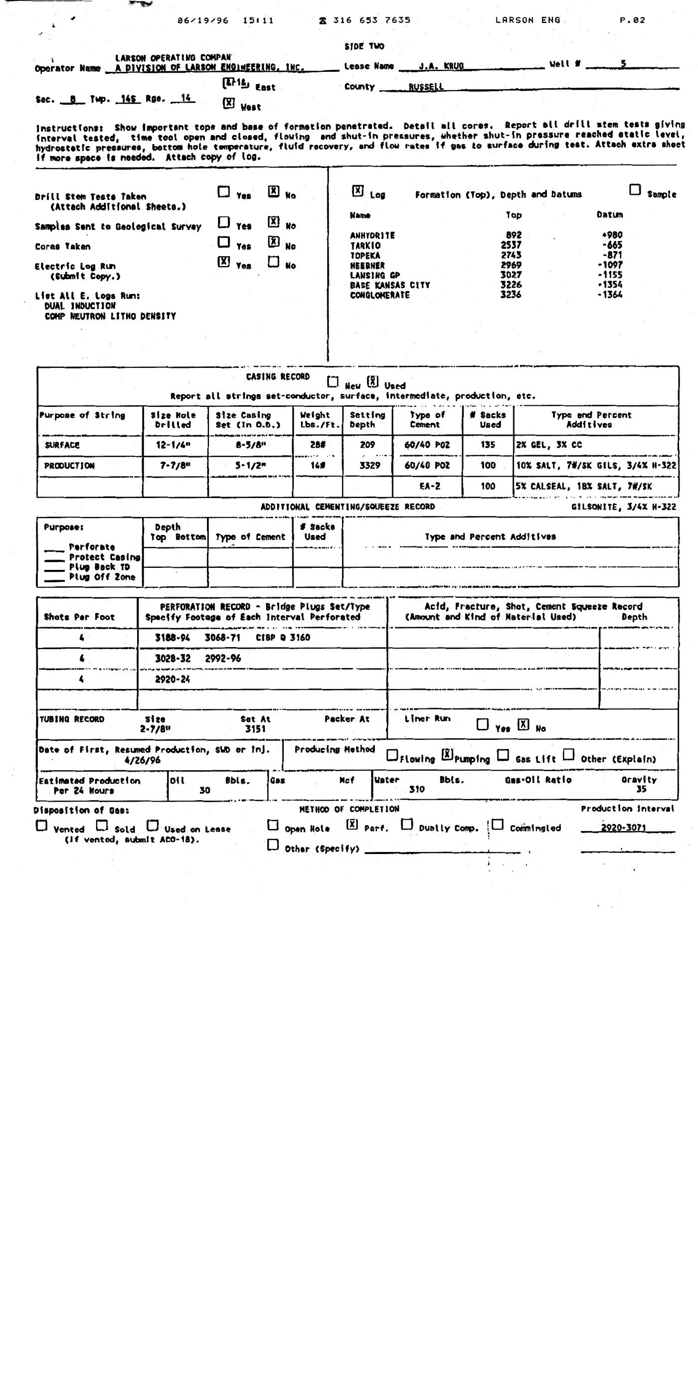
| 8.625 0.95 | 209.0 0.95 | 135.0 0.95 | SURFACE 0.95 | p. 2 | 8-5/8 |
| 5.5 0.95 | 3329.0 0.95 | 100.0 0.95 | PRODUCTION 0.95 | p. 2 | 5-1/2 |
Perforations
| Top (ft) | Bottom (ft) | Formation | Page | Snippet |
|---|---|---|---|---|
| 3188.0 0.95 | 3194.0 0.95 | p. 2 | 3188-94 | |
| 3068.0 0.95 | 3071.0 0.95 | p. 2 | 3068-71 | |
| 3028.0 0.95 | 3032.0 0.95 | p. 2 | 3028-32 | |
| 2992.0 0.95 | 2996.0 0.95 | p. 2 | 2992-96 | |
| 2920.0 0.95 | 2924.0 0.95 | p. 2 | 2920-24 |
Formation tops
| Formation | Depth (ft) | Page | Snippet |
|---|---|---|---|
| ANHYDRITE 0.95 | 892.0 0.95 | p. 2 | ANHYORITE |
| TARKIO 0.95 | 2537.0 0.95 | p. 2 | TARKIO |
| TOPEKA 0.95 | 2743.0 0.95 | p. 2 | TOPEKA |
| HEEBNER 0.95 | 2969.0 0.95 | p. 2 | HEEBNER |
| LANSING GP 0.95 | 3027.0 0.95 | p. 2 | LANSING GP |
| BASE KANSAS CITY 0.95 | 3226.0 0.95 | p. 2 | BASE KANSAS CITY |
| CONGLOMERATE 0.95 | 3236.0 0.95 | p. 2 | CONGLOMERATE |
Tests (DST / IP)
None extracted.
QC flags
| Severity | Rule | Field | Message | Expert review |
|---|---|---|---|---|
| warning | VALUE_NOT_IN_SNIPPET | api_number | api_number: '15-167-23113' does not appear in its snippet 'API NO. 15- 167-23 -- 0000' | yes |