
Mai #6 SWD 15-167-21117 · Russell County needs expert review
Document 15-167-21117_ACO · 4 page(s) · read with option layout · source scan (KGS).
Click a row to highlight where it was read on the scan. Read-only (Phase 1).
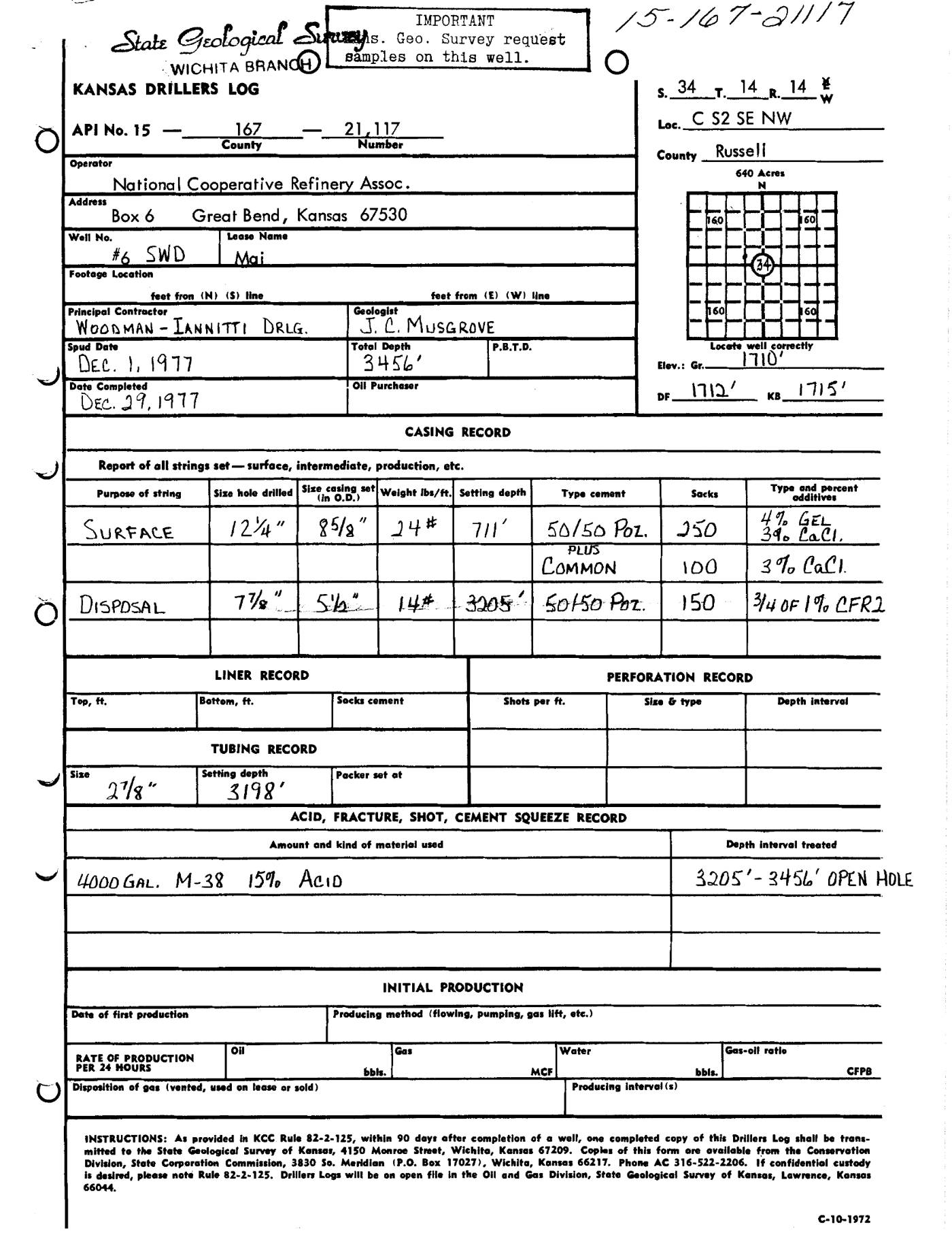 page 1
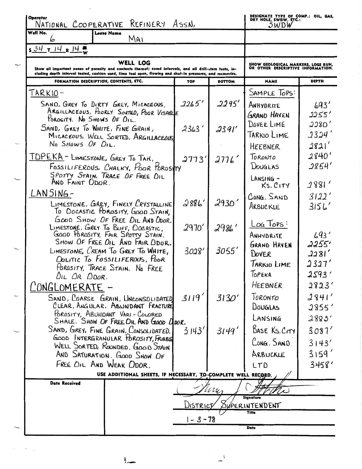 page 2
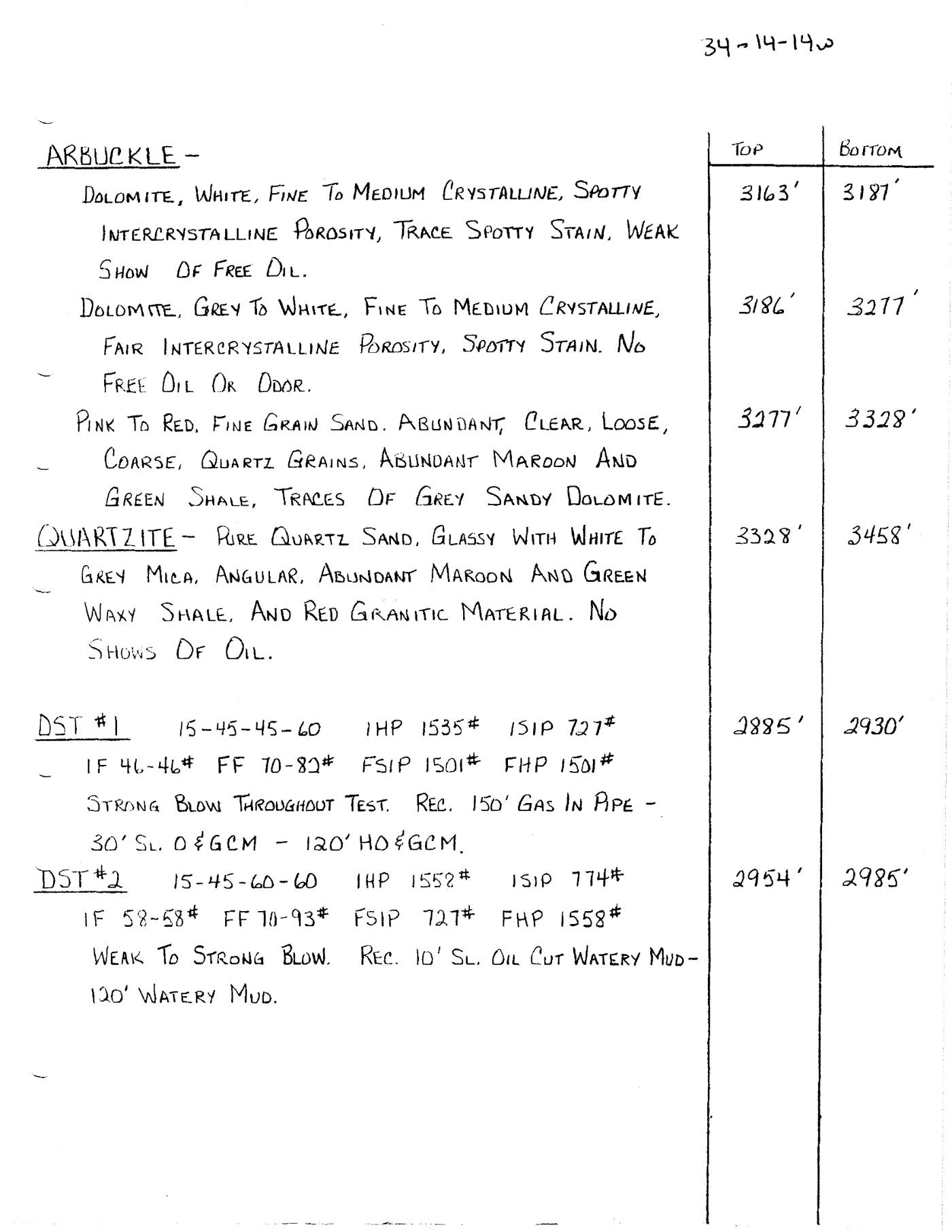 page 3
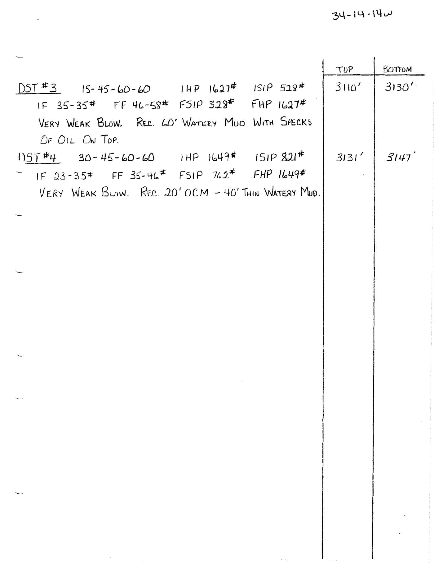 page 4
Extracted fields & KGS master-list cross-check
| Field | Value | Confidence | Page | Snippet | Cross-check |
|---|---|---|---|---|---|
| Document type | driller's log | 0.95 | p. 1 | KANSAS DRILLERS LOG | |
| API number | 15-167-21117 | 1.00 | p. 1 | API No. 15 167 - 21,117 | match KGS: 15-167-21117 |
| Lease | Mai | 1.00 | p. 1 | Lease Name Mai | match KGS: Mai |
| Well no. | #6 SWD | 1.00 | p. 1 | Well No. #6 SWD | mismatch KGS: 6 |
| Operator | National Cooperative Refinery Assoc. | 1.00 | p. 1 | Operator National Cooperative Refinery Assoc. | match KGS: Natl. Coop. Refinery Assoc. / BEREXCO LLC |
| County | Russell | 1.00 | p. 1 | County Russell | match KGS: Russell |
| Location | C S2 SE NW 34-14S-14W | 0.98 | p. 1 | Loc. C S2 SE NW | match KGS: 34-14S-14W |
| Section | 34 (as written: C S2 SE NW 34-14S-14W) | 0.98 | p. 1 | Loc. C S2 SE NW | |
| Township | 14S (as written: C S2 SE NW 34-14S-14W) | 0.98 | p. 1 | Loc. C S2 SE NW | |
| Range | 14W (as written: C S2 SE NW 34-14S-14W) | 0.98 | p. 1 | Loc. C S2 SE NW | |
| Spud date | 1977-12-01 (as written: DEC. 1, 1977) | 1.00 | p. 1 | Spud Date DEC. 1, 1977 | match KGS: 01-DEC-1977 |
| Completion date | 1977-12-29 (as written: DEC. 29, 1977) | 1.00 | p. 1 | Date Completed DEC. 29, 1977 | mismatch KGS: 10-DEC-1977 |
| Plug date | missing extracted | ||||
| Elevation KB (ft) | 1715.0 (as written: 1715') | 1.00 | p. 1 | KB 1715' | match KGS: 1715 KB |
| Elevation DF (ft) | 1712.0 (as written: 1712') | 1.00 | p. 1 | DF 1712' | |
| Elevation ground (ft) | 1710.0 (as written: 1710') | 1.00 | p. 1 | Elev.: Gr. 1710' | |
| Elevation, no reference (ft) | |||||
| Total depth (ft) | 3456.0 (as written: 3456') | 1.00 | p. 1 | Total Depth 3456' | match KGS: 3456 |
| Plugging |
Casing
| Size (in) | Depth (ft) | Cement (sx) | Purpose | Page | Snippet |
|---|---|---|---|---|---|
| 8.625 0.95 | 711.0 1.00 | 250.0 1.00 | SURFACE 1.00 | p. 1 | 85/8' |
| 5.5 1.00 | 3205.0 1.00 | 150.0 1.00 | DISPOSAL 1.00 | p. 1 | 5 1/2" |
Perforations
None extracted.
Formation tops
| Formation | Depth (ft) | Page | Snippet |
|---|---|---|---|
| Anhydrite 1.00 | 693.0 1.00 | p. 2 | ANHYDRITE |
| Grand Haven 1.00 | 2255.0 1.00 | p. 2 | GRAND HAVEN |
| Dover Lime 1.00 | 2280.0 1.00 | p. 2 | DOVER LIME |
| Tarkio Lime 1.00 | 2327.0 1.00 | p. 2 | TARKIO LIME |
| Heebner 1.00 | 2821.0 1.00 | p. 2 | HEEBNER |
| Toronto 1.00 | 2840.0 1.00 | p. 2 | TORONTO |
| Douglas 1.00 | 2854.0 1.00 | p. 2 | DOUGLAS |
| Lansing-Ks. City 1.00 | 2881.0 1.00 | p. 2 | LANSING - KS. CITY |
| Cong. Sand 1.00 | 3122.0 1.00 | p. 2 | CONG. SAND |
| Arbuckle 1.00 | 3156.0 1.00 | p. 2 | ARBUCKLE |
| LTD 1.00 | 3458.0 1.00 | p. 2 | LTD |
| Base Ks. City 1.00 | 3087.0 1.00 | p. 2 | BASE KS. CITY |
| Cong. Sand 1.00 | 3143.0 1.00 | p. 2 | CONG. SAND |
| Arbuckle 1.00 | 3159.0 1.00 | p. 2 | ARBUCKLE |
| Tarkio 1.00 | 2324.0 1.00 | p. 2 | TARKIO |
| Topeka 1.00 | 2593.0 1.00 | p. 2 | TOPEKA |
| Heebner 1.00 | 2823.0 1.00 | p. 2 | HEEBNER |
| Toronto 1.00 | 2841.0 1.00 | p. 2 | TORONTO |
| Douglas 1.00 | 2855.0 1.00 | p. 2 | DOUGLAS |
| Lansing 1.00 | 2883.0 1.00 | p. 2 | LANSING |
| Cong. Sand 1.00 | 3143.0 1.00 | p. 2 | CONG. SAND |
| Arbuckle 1.00 | 3159.0 1.00 | p. 2 | ARBUCKLE |
| LTD 1.00 | 3458.0 1.00 | p. 2 | LTD |
| Tarkio 1.00 | 2327.0 1.00 | p. 2 | TARKIO |
| Topeka 1.00 | 2773.0 1.00 | p. 2 | TOPEKA |
| Lansing 1.00 | 2886.0 1.00 | p. 2 | LANSING |
| Conglomerate 1.00 | 3119.0 1.00 | p. 2 | CONGLOMERATE |
| Conglomerate 1.00 | 3143.0 1.00 | p. 2 | CONGLOMERATE |
Tests (DST / IP)
| Kind | Top (ft) | Bottom (ft) | Result | Page | Snippet |
|---|---|---|---|---|---|
| DST #1 1.00 | 2885.0 1.00 | 2930.0 1.00 | Strong blow throughout test. Rec. 150' gas in pipe - 30' SL. O&GCM - 120' HO&GCM. 0.95 | p. 3 | DST # 1 |
| DST #2 1.00 | 2954.0 1.00 | 2985.0 1.00 | Weak to strong blow. Rec. 10' SL. Oil cut watery mud - 120' watery mud. 0.95 | p. 3 | DST #2 |
| DST #3 1.00 | 3110.0 1.00 | 3130.0 1.00 | Very weak blow. Rec. 60' watery mud with specks of oil on top. 0.95 | p. 4 | DST # 3 |
| DST #4 1.00 | 3131.0 1.00 | 3147.0 1.00 | Very weak blow. Rec. 20' OCM - 40' thin watery mud. 0.95 | p. 4 | DST # 4 |
QC flags
| Severity | Rule | Field | Message | Expert review |
|---|---|---|---|---|
| error | TOP_BELOW_TD | tops[10] | Top LTD at 3458 ft is below TD 3456 ft | yes |
| error | TOP_BELOW_TD | tops[22] | Top LTD at 3458 ft is below TD 3456 ft | yes |
| warning | TOPS_ORDER | tops[11] | Top Base Ks. City at 3087 ft is shallower than preceding LTD at 3458 ft | yes |
| warning | TOPS_ORDER | tops[14] | Top Tarkio at 2324 ft is shallower than preceding Arbuckle at 3159 ft | yes |
| warning | TOPS_ORDER | tops[23] | Top Tarkio at 2327 ft is shallower than preceding LTD at 3458 ft | yes |