
LOUIE "A" 8 15-167-20986 · Russell County
Document 15-167-20986-0001_ACO · 2 page(s) · read with option layout · source scan (KGS).
Click a row to highlight where it was read on the scan. Read-only (Phase 1).
 page 1
 page 2
Extracted fields & KGS master-list cross-check
| Field | Value | Confidence | Page | Snippet | Cross-check |
|---|---|---|---|---|---|
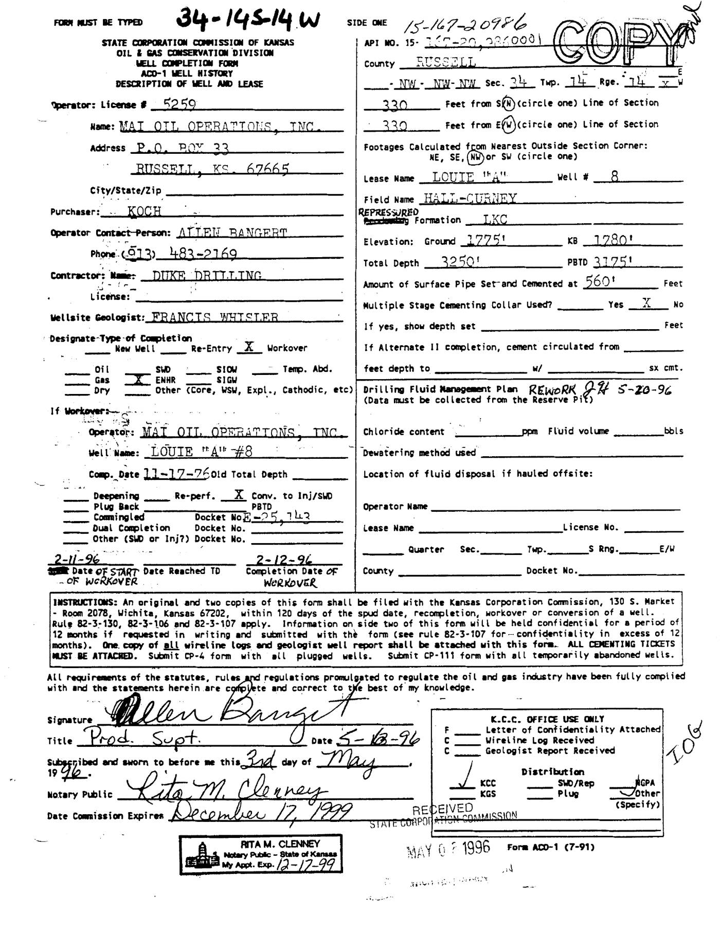
| Document type | well completion form | 1.00 | p. 1 | WELL COMPLETION FORM ACO-1 WELL HISTORY DESCRIPTION OF WELL AND LEASE | |
| API number | 15-167-20986 | 0.95 | p. 1 | API NO. 15-167-20986 | match KGS: 15-167-20986 |
| Lease | LOUIE "A" | 0.98 | p. 1 | Lease Name LOUIE "A" | match KGS: Louie 'A' |
| Well no. | 8 | 0.98 | p. 1 | Well # 8 | match KGS: 8 |
| Operator | MAT OIL OPERATIONS, INC. | 0.98 | p. 1 | Name: MAT OIL OPERATIONS, INC. | match KGS: Mai Oil Operations, Inc. / Mai Oil Operations, Inc. |
| County | Russell (as written: RUSSELL) | 0.98 | p. 1 | County RUSSELL | match KGS: Russell |
| Location | NW NW NW Sec. 34 Twp. 14 Rge. 14W 330' FNL 330' FWL | 0.95 | p. 1 | - NW - NW- NW Sec. 34 Twp. 14 Rge. 14 W 330 Feet from S(N) (circle one) Line of Section 330 Feet from E(W) (circle one) Line of Section | match KGS: 34-14S-14W |
| Section | 34 (as written: NW NW NW Sec. 34 Twp. 14 Rge. 14W 330' FNL 330' FWL) | 0.95 | p. 1 | - NW - NW- NW Sec. 34 Twp. 14 Rge. 14 W 330 Feet from S(N) (circle one) Line of Section 330 Feet from E(W) (circle one) Line of Section | |
| Township | 14S (as written: NW NW NW Sec. 34 Twp. 14 Rge. 14W 330' FNL 330' FWL) | 0.95 | p. 1 | - NW - NW- NW Sec. 34 Twp. 14 Rge. 14 W 330 Feet from S(N) (circle one) Line of Section 330 Feet from E(W) (circle one) Line of Section | |
| Range | 14W (as written: NW NW NW Sec. 34 Twp. 14 Rge. 14W 330' FNL 330' FWL) | 0.95 | p. 1 | - NW - NW- NW Sec. 34 Twp. 14 Rge. 14 W 330 Feet from S(N) (circle one) Line of Section 330 Feet from E(W) (circle one) Line of Section | |
| Spud date | p. 1 | missing extracted KGS: 11-NOV-1976 | |||
| Completion date | 1996-02-12 (as written: 2-12-96) | 0.95 | p. 1 | Completion Date OF WORKOVER 2-12-96 | mismatch KGS: 15-DEC-1976 |
| Plug date | p. 1 | missing extracted | |||
| Elevation KB (ft) | 1280.0 (as written: 1280') | 0.95 | p. 1 | KB 1280' | mismatch KGS: 1780 KB |
| Elevation DF (ft) | p. 1 | ||||
| Elevation ground (ft) | 1275.0 (as written: 1275') | 0.95 | p. 1 | Elevation: Ground 1275' | |
| Elevation, no reference (ft) | p. 1 | ||||
| Total depth (ft) | 3250.0 (as written: 3250') | 0.95 | p. 1 | Total Depth 3250' | match KGS: 3250 |
| Plugging | p. 1 |
Casing
| Size (in) | Depth (ft) | Cement (sx) | Purpose | Page | Snippet |
|---|---|---|---|---|---|
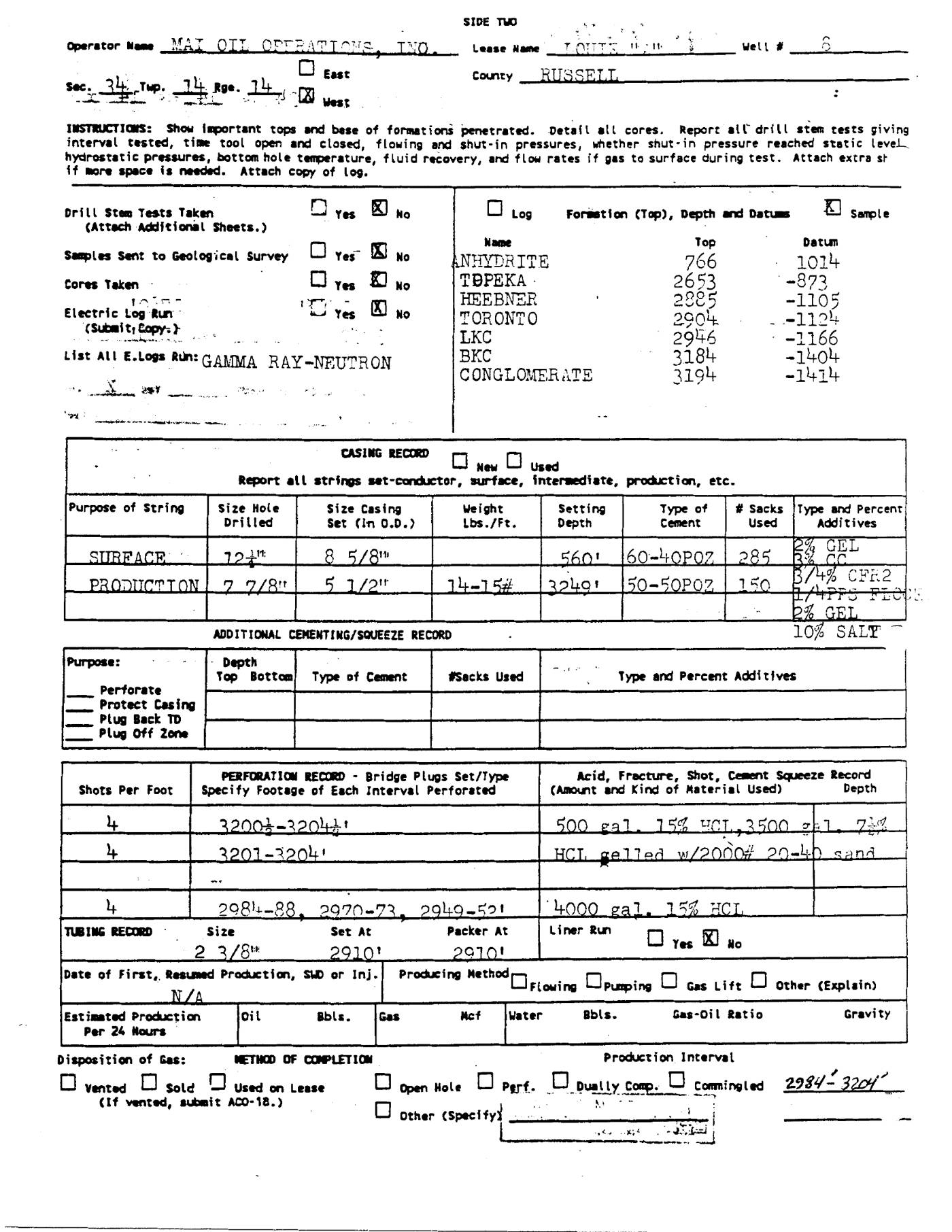
| 8.625 0.95 | 560.0 0.95 | 285.0 0.95 | SURFACE 0.95 | p. 2 | 8 5/8" |
| 5.5 0.95 | 3240.0 0.95 | 150.0 0.95 | PRODUCTION 0.95 | p. 2 | 5 1/2" |
Perforations
| Top (ft) | Bottom (ft) | Formation | Page | Snippet |
|---|---|---|---|---|
| 3200.0 0.90 | 3204.0 0.90 | p. 2 | 3200-3204' | |
| 2984.0 0.90 | 2988.0 0.90 | p. 2 | 2984-88 | |
| 2970.0 0.90 | 2973.0 0.90 | p. 2 | 2970-73 | |
| 2949.0 0.90 | 2952.0 0.90 | p. 2 | 2949-52 |
Formation tops
| Formation | Depth (ft) | Page | Snippet |
|---|---|---|---|
| ANHYDRITE 0.95 | 766.0 0.95 | p. 2 | ANHYDRITE |
| TOPEKA 0.95 | 2653.0 0.95 | p. 2 | TOPEKA |
| HEEBNER 0.95 | 2885.0 0.95 | p. 2 | HEEBNER |
| TORONTO 0.95 | 2904.0 0.95 | p. 2 | TORONTO |
| LKC 0.95 | 2946.0 0.95 | p. 2 | LKC |
| BKC 0.95 | 3184.0 0.95 | p. 2 | BKC |
| CONGLOMERATE 0.95 | 3194.0 0.95 | p. 2 | CONGLOMERATE |
Tests (DST / IP)
None extracted.
QC flags
No QC flags.