
Schmidt 001 15-051-23207 · Ellis County needs expert review
Document 15-051-23207_ACO · 3 page(s) · read with option layout · source scan (KGS).
Click a row to highlight where it was read on the scan. Read-only (Phase 1).
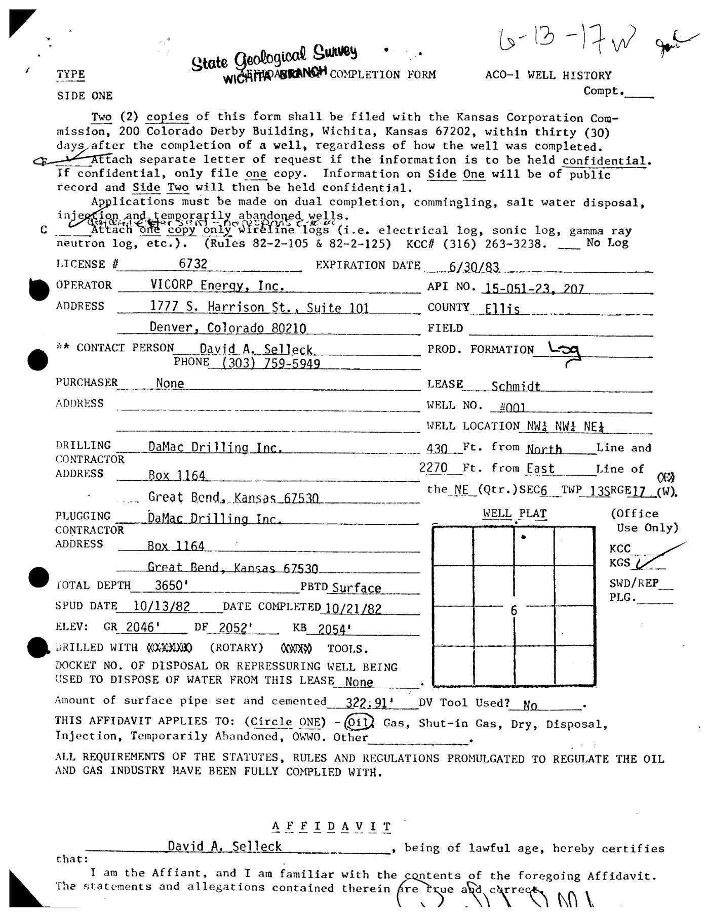 page 1
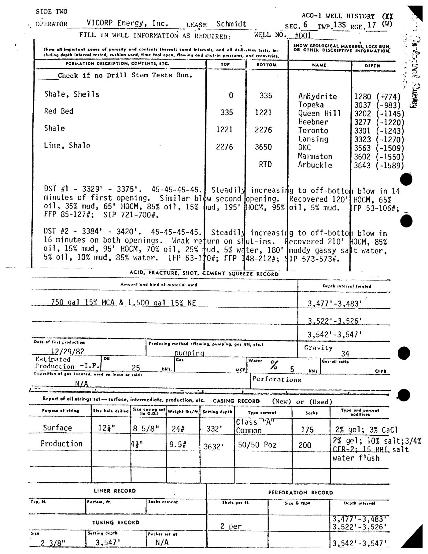 page 2
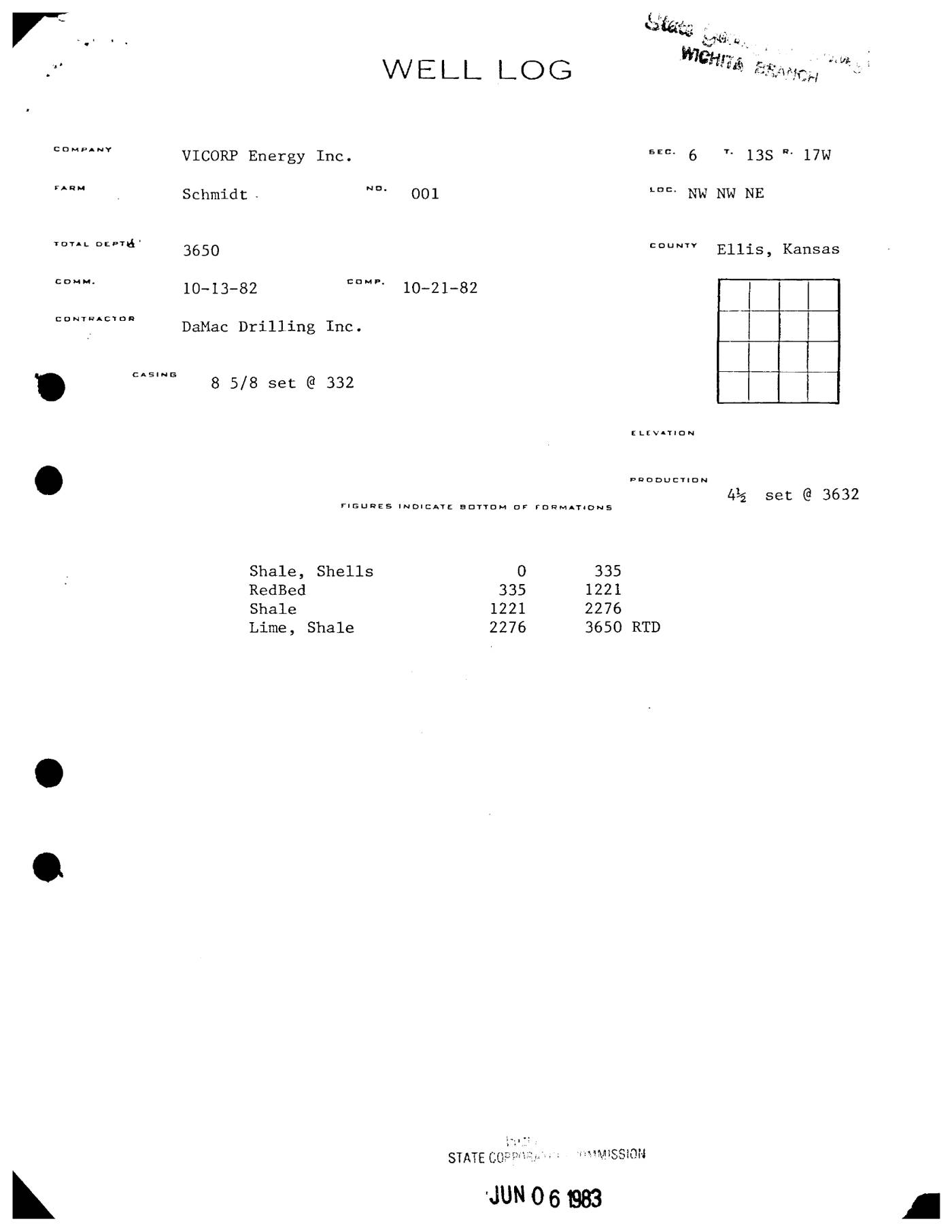 page 3
Extracted fields & KGS master-list cross-check
| Field | Value | Confidence | Page | Snippet | Cross-check |
|---|---|---|---|---|---|
| Document type | well completion form | 0.95 | p. 1 | State Geological Survey ... COMPLETION FORM ... ACO-1 WELL HISTORY | |
| API number | 15-051-23207 | 0.98 | p. 1 | API NO. 15-051-23, 207 | match KGS: 15-051-23207 |
| Lease | Schmidt | 0.98 | p. 1 | LEASE Schmidt | match KGS: SCHMIDT |
| Well no. | 001 | 0.98 | p. 1 | WELL NO. #001 | match KGS: 1 |
| Operator | VICORP Energy, Inc. | 0.98 | p. 1 | OPERATOR VICORP Energy, Inc. | match KGS: VICORP ENERGY / Trans Pacific Oil Corporation |
| County | Ellis | 0.98 | p. 1 | COUNTY Ellis | match KGS: Ellis |
| Location | NW NW NE Sec 6 TWP 13S RGE 17W | 0.95 | p. 1 | WELL LOCATION NWA NWA NEA ... the NE (Qtr.)SEC6 TWP 13SRGE17.(W). | match KGS: 6-13S-17W |
| Section | 6 (as written: NW NW NE Sec 6 TWP 13S RGE 17W) | 0.95 | p. 1 | WELL LOCATION NWA NWA NEA ... the NE (Qtr.)SEC6 TWP 13SRGE17.(W). | |
| Township | 13S (as written: NW NW NE Sec 6 TWP 13S RGE 17W) | 0.95 | p. 1 | WELL LOCATION NWA NWA NEA ... the NE (Qtr.)SEC6 TWP 13SRGE17.(W). | |
| Range | 17W (as written: NW NW NE Sec 6 TWP 13S RGE 17W) | 0.95 | p. 1 | WELL LOCATION NWA NWA NEA ... the NE (Qtr.)SEC6 TWP 13SRGE17.(W). | |
| Spud date | 1982-10-13 (as written: 10/13/82) | 0.98 | p. 1 | SPUD DATE 10/13/82 | match KGS: 13-OCT-1982 |
| Completion date | 1982-10-21 (as written: 10/21/82) | 0.98 | p. 1 | DATE COMPLETED 10/21/82 | mismatch KGS: 12-MAY-1983 |
| Plug date | p. 1 | missing extracted KGS: 22-AUG-2008 | |||
| Elevation KB (ft) | 2054.0 (as written: 2054) | 0.95 | p. 1 | KB 2054' | match KGS: 2054 KB |
| Elevation DF (ft) | 2052.0 (as written: 2052) | 0.95 | p. 1 | DF 2052' | |
| Elevation ground (ft) | 2046.0 (as written: 2046) | 0.95 | p. 1 | GR 2046' | |
| Elevation, no reference (ft) | p. 1 | ||||
| Total depth (ft) | 3650.0 (as written: 3650) | 0.98 | p. 1 | TOTAL DEPTH 3650' | match KGS: 3650 |
| Plugging | p. 1 |
Casing
| Size (in) | Depth (ft) | Cement (sx) | Purpose | Page | Snippet |
|---|---|---|---|---|---|
| 8.625 0.69 | 332.0 0.98 | Surface 0.98 | p. 1 | 8 5/8" | |
| 4.5 0.95 | 3632.0 0.98 | 50.0 0.95 | Production 0.98 | p. 2 | 4 1/2" |
Perforations
| Top (ft) | Bottom (ft) | Formation | Page | Snippet |
|---|---|---|---|---|
| 3477.0 0.98 | 3483.0 0.98 | p. 2 | 3,477'-3,483' | |
| 3522.0 0.98 | 3526.0 0.98 | p. 2 | 3,522'-3,526' | |
| 3542.0 0.98 | 3547.0 0.98 | p. 2 | 3,542'-3,547' |
Formation tops
| Formation | Depth (ft) | Page | Snippet |
|---|---|---|---|
| Shale, Shells 0.98 | 335.0 0.98 | p. 2 | Shale, Shells |
| Red Bed 0.98 | 1221.0 0.98 | p. 2 | Red Bed |
| Shale 0.98 | 2276.0 0.98 | p. 2 | Shale |
| Lime, Shale 0.98 | 3650.0 0.98 | p. 2 | Lime, Shale |
| Anhydrite 0.98 | 1280.0 0.98 | p. 2 | Anhydrite |
| Topeka 0.98 | 3037.0 0.98 | p. 2 | Topeka |
| Queen Hill 0.98 | 3202.0 0.98 | p. 2 | Queen Hill |
| Heebner 0.98 | 3277.0 0.98 | p. 2 | Heebner |
| Toronto 0.98 | 3301.0 0.98 | p. 2 | Toronto |
| Lansing 0.98 | 3323.0 0.98 | p. 2 | Lansing |
| BKC 0.98 | 3563.0 0.98 | p. 2 | BKC |
| Marmaton 0.98 | 3602.0 0.98 | p. 2 | Marmaton |
| Arbuckle 0.98 | 3643.0 0.98 | p. 2 | Arbuckle |
Tests (DST / IP)
| Kind | Top (ft) | Bottom (ft) | Result | Page | Snippet |
|---|---|---|---|---|---|
| DST #1 0.66 | 3329.0 0.69 | 3375.0 0.69 | Steadily increasing to off-bottom blow in 14 minutes...Recovered 120' HOCM, 65% oil, 35% mud, 65' HOCM, 85% oil, 15% mud, 195' HOCM, 95% oil, 5% mud. FP 53-106#; FFP 85-127#; SIP 721-700#. 0.90 | p. 2 | DST #1 - 3329' - 3375' |
| DST #2 0.95 | 3384.0 0.98 | 3420.0 0.98 | Steadily increasing to off-bottom blow in 16 minutes...Recovered 210' HOCM, 85% oil, 15% mud, 95' HOCM, 70% oil, 25% mud, 5% water, 180' muddy gassy salt water, 5% oil, 10% mud, 85% water. IFP 63-110#; FFP 148-212#; SIP 573-573#. 0.90 | p. 2 | DST #2 - 3384' - 3420' |
| Initial Potential 0.95 | 25 bbl oil, 5 bbl water, 5% gas, pumping, gravity 34 0.66 | p. 2 | Estimated Production -I.P. |
QC flags
| Severity | Rule | Field | Message | Expert review |
|---|---|---|---|---|
| warning | TOPS_ORDER | tops[4] | Top Anhydrite at 1280 ft is shallower than preceding Lime, Shale at 3650 ft | yes |