
Lester V. Irvin #2 15-051-23204 · Ellis County needs expert review
Document 15-051-23204_ACO · 2 page(s) · read with option layout · source scan (KGS).
Click a row to highlight where it was read on the scan. Read-only (Phase 1).
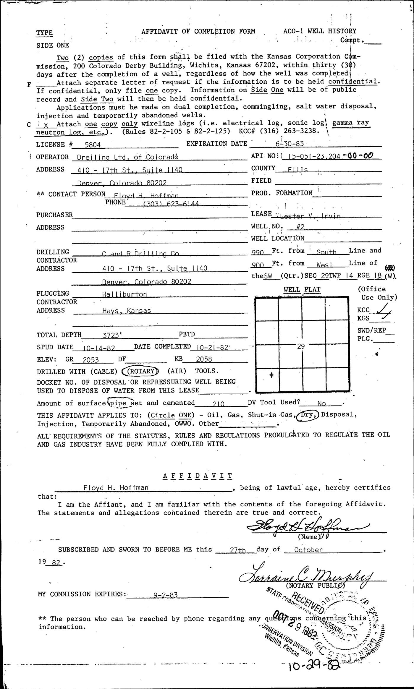 page 1
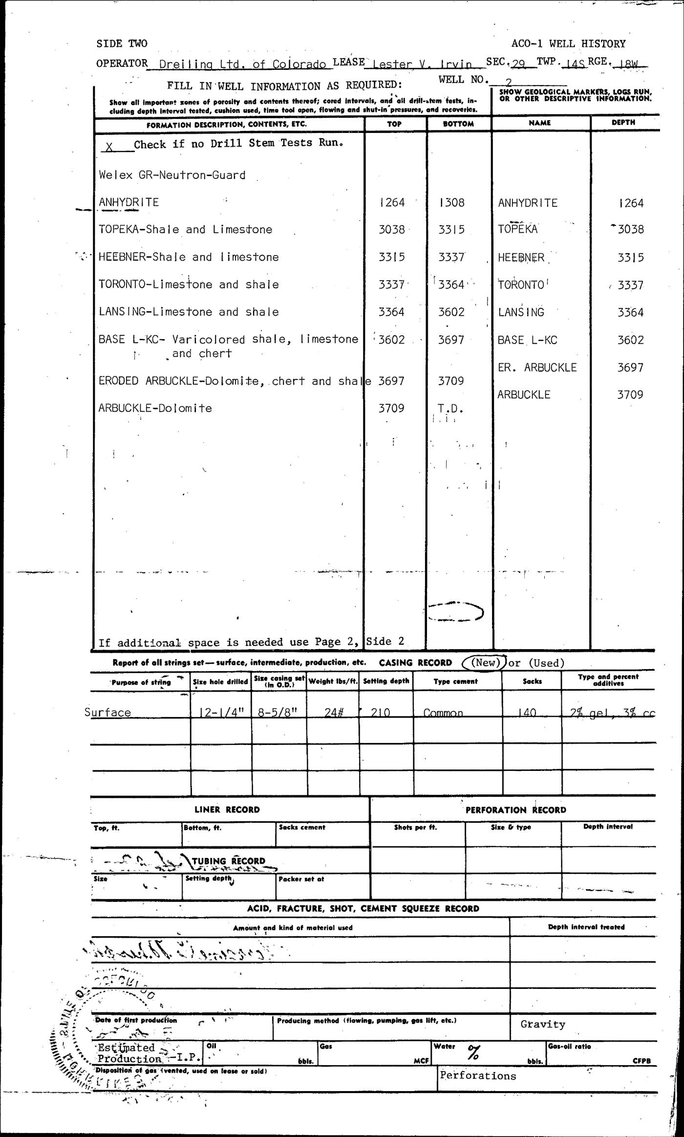 page 2
Extracted fields & KGS master-list cross-check
| Field | Value | Confidence | Page | Snippet | Cross-check |
|---|---|---|---|---|---|
| Document type | well completion form | 0.98 | p. 1 | AFFIDAVIT OF COMPLETION FORM ACO-1 WELL HISTORY | |
| API number | 15-051-23204 (as written: 15-051-23204-00-00) | 0.97 | p. 1 | API NO: 15-05-23,204-00-00 | match KGS: 15-051-23204 |
| Lease | Lester V. Irvin | 0.96 | p. 1 | LEASE Lester V. Irvin | match KGS: Irvin, Lester V. |
| Well no. | #2 | 0.97 | p. 1 | WELL, NO, #2 | match KGS: 2 |
| Operator | Dreiling Ltd. of Colorado | 0.98 | p. 1 | OPERATOR Dreiling Ltd. of Colorado | match KGS: Dreiling Ltd of Colorado / Dreiling Ltd. of Colorado |
| County | Ellis | 0.97 | p. 1 | COUNTY FILis | match KGS: Ellis |
| Location | 990 Ft. from South Line and 900 Ft. from West Line of the SW (Qtr.) SEC 29 TWP 14 RGE 18 (W) snippet not found in OCR text | 0.68 | p. 1 | WELL LOCATION 990 Ft. from South Line and 900 Ft. from West Line of the SW (Qtr.) SEC 29 TWP 14 RGE 18 (W) | missing extracted KGS: 29-14S-18W |
| Section | |||||
| Township | |||||
| Range | |||||
| Spud date | 1982-10-14 (as written: 10-14-82) | 0.98 | p. 1 | SPUD DATE 10-14-82 | match KGS: 14-OCT-1982 |
| Completion date | 1982-10-21 (as written: 10-21-82) | 0.98 | p. 1 | DATE COMPLETED 10-21-82 | match KGS: 21-OCT-1982 |
| Plug date | p. 1 | missing extracted KGS: 21-OCT-1982 | |||
| Elevation KB (ft) | 2058.0 (as written: 2058) | 0.97 | p. 1 | KB 2058 | match KGS: 2058 KB |
| Elevation DF (ft) | p. 1 | DF | |||
| Elevation ground (ft) | 2053.0 (as written: 2053) | 0.97 | p. 1 | ELEV: GR 2053 | |
| Elevation, no reference (ft) | p. 1 | ||||
| Total depth (ft) | 3723.0 (as written: 3723') | 0.98 | p. 1 | TOTAL DEPTH 3723' | match KGS: 3723 |
| Plugging | p. 1 |
Casing
| Size (in) | Depth (ft) | Cement (sx) | Purpose | Page | Snippet |
|---|---|---|---|---|---|
| 8.625 0.97 | 210.0 0.97 | 140.0 0.97 | Surface 0.97 | p. 2 | 8-5/8" |
Perforations
None extracted.
Formation tops
| Formation | Depth (ft) | Page | Snippet |
|---|---|---|---|
| ANHYDRITE 0.97 | 1264.0 0.97 | p. 2 | ANHYDRITE |
| TOPEKA 0.97 | 3038.0 0.97 | p. 2 | TOPEKA |
| HEEBNER 0.97 | 3315.0 0.97 | p. 2 | HEEBNER |
| TORONTO 0.97 | 3337.0 0.97 | p. 2 | TORONTO' |
| LANSING 0.97 | 3364.0 0.97 | p. 2 | LANSING |
| BASE L-KC 0.97 | 3602.0 0.97 | p. 2 | BASE L-KC |
| ER. ARBUCKLE 0.97 | 3697.0 0.97 | p. 2 | ER. ARBUCKLE |
| ARBUCKLE 0.97 | 3709.0 0.97 | p. 2 | ARBUCKLE |
Tests (DST / IP)
None extracted.
QC flags
| Severity | Rule | Field | Message | Expert review |
|---|---|---|---|---|
| warning | LOCATION_FORMAT | location | Location '990 Ft. from South Line and 900 Ft. from West Line of the SW (Qtr.) SEC 29 TWP 14 RGE 18 (W)' has no parseable Sec-Twp-Rge | yes |
| warning | SNIPPET_UNVERIFIED | location | location: cited snippet not found on page 1 | yes |
| warning | VALUE_NOT_IN_SNIPPET | api_number | api_number: '15-051-23204-00-00' does not appear in its snippet 'API NO: 15-05-23,204-00-00' | yes |