
Wiesner "A" 1 15-051-21501 · Ellis County
Document 15-051-21501_ACO · 2 page(s) · read with option layout · source scan (KGS).
Click a row to highlight where it was read on the scan. Read-only (Phase 1).
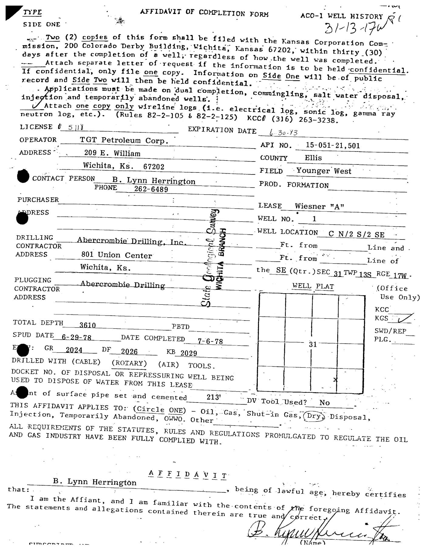 page 1
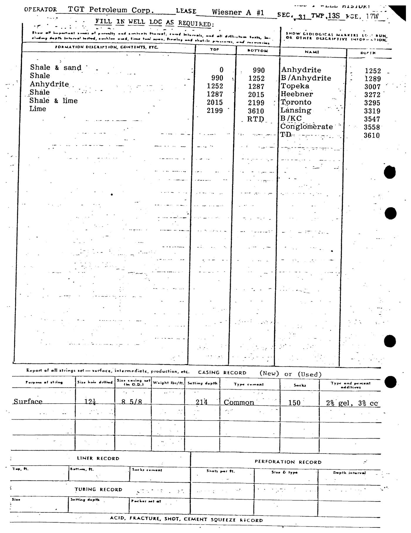 page 2
Extracted fields & KGS master-list cross-check
| Field | Value | Confidence | Page | Snippet | Cross-check |
|---|---|---|---|---|---|
| Document type | well completion form (as written: AFFIDAVIT OF COMPLETION FORM) | 1.00 | p. 1 | AFFIDAVIT OF COMPLETION FORM ACO-1 WELL HISTORY | |
| API number | 15-051-21501 (as written: 15-051-21,501) | 1.00 | p. 1 | API NO. 15-051-21,501 | match KGS: 15-051-21501 |
| Lease | Wiesner "A" | 1.00 | p. 1 | LEASE Wiesner "A" | match KGS: WIESNER 'A' |
| Well no. | 1 | 1.00 | p. 1 | WELL NO. 1 | match KGS: 1 |
| Operator | TGT Petroleum Corp. | 1.00 | p. 1 | OPERATOR TGT Petroleum Corp. | match KGS: T G T PETROLEUM CORP. |
| County | Ellis | 1.00 | p. 1 | COUNTY Ellis | match KGS: Ellis |
| Location | C N/2 S/2 SE the SE (Qtr.) SEC 31 TWP 13S RGE 17W | 0.95 | p. 1 | WELL LOCATION C N/2 S/2 SE ...the SE (Qtr.) SEC 31 TWP 13S RGE 17W | match KGS: 31-13S-17W |
| Section | 31 (as written: C N/2 S/2 SE the SE (Qtr.) SEC 31 TWP 13S RGE 17W) | 0.95 | p. 1 | WELL LOCATION C N/2 S/2 SE ...the SE (Qtr.) SEC 31 TWP 13S RGE 17W | |
| Township | 13S (as written: C N/2 S/2 SE the SE (Qtr.) SEC 31 TWP 13S RGE 17W) | 0.95 | p. 1 | WELL LOCATION C N/2 S/2 SE ...the SE (Qtr.) SEC 31 TWP 13S RGE 17W | |
| Range | 17W (as written: C N/2 S/2 SE the SE (Qtr.) SEC 31 TWP 13S RGE 17W) | 0.95 | p. 1 | WELL LOCATION C N/2 S/2 SE ...the SE (Qtr.) SEC 31 TWP 13S RGE 17W | |
| Spud date | 1978-06-29 (as written: 6-29-78) | 1.00 | p. 1 | SPUD DATE 6-29-78 | match KGS: 29-JUN-1978 |
| Completion date | 1978-07-06 (as written: 7-6-78) | 1.00 | p. 1 | DATE COMPLETED 7-6-78 | match KGS: 06-JUL-1978 |
| Plug date | p. 1 | missing extracted KGS: 31-JUL-1978 | |||
| Elevation KB (ft) | 2029.0 (as written: 2029) | 1.00 | p. 1 | KB 2029 | match KGS: 2029 KB |
| Elevation DF (ft) | 2026.0 (as written: 2026) | 1.00 | p. 1 | DF 2026 | |
| Elevation ground (ft) | p. 1 | ||||
| Elevation, no reference (ft) | p. 1 | ||||
| Total depth (ft) | 3610.0 (as written: 3610) | 1.00 | p. 1 | TOTAL DEPTH 3610 | match KGS: 3610 |
| Plugging | p. 1 |
Casing
| Size (in) | Depth (ft) | Cement (sx) | Purpose | Page | Snippet |
|---|---|---|---|---|---|
| 8.625 0.95 | 214.0 0.95 | 150.0 0.95 | Surface 0.95 | p. 2 | 8 5/8 |
Perforations
None extracted.
Formation tops
| Formation | Depth (ft) | Page | Snippet |
|---|---|---|---|
| Anhydrite 0.95 | 1252.0 0.95 | p. 2 | Anhydrite | 1252 |
| B/Anhydrite 0.95 | 1289.0 0.95 | p. 2 | B/Anhydrite | 1289 |
| Topeka 0.95 | 3007.0 0.95 | p. 2 | Topeka | 3007 |
| Heebner 0.95 | 3272.0 0.95 | p. 2 | Heebner | 3272 |
| Toronto 0.95 | 3295.0 0.95 | p. 2 | Toronto | 3295 |
| Lansing 0.95 | 3319.0 0.95 | p. 2 | Lansing | 3319 |
| B/KC 0.95 | 3547.0 0.95 | p. 2 | B/KC | 3547 |
| Conglomerate 0.95 | 3558.0 0.95 | p. 2 | Conglomerate | 3558 |
| T-D- 0.95 | 3610.0 0.95 | p. 2 | T-D- | 3610 |
Tests (DST / IP)
None extracted.
QC flags
No QC flags.