
Staab "A" 4 15-051-20129 · Ellis County needs expert review
Document 15-051-20129_DL · 1 page(s) · read with option layout · source scan (KGS).
Click a row to highlight where it was read on the scan. Read-only (Phase 1).
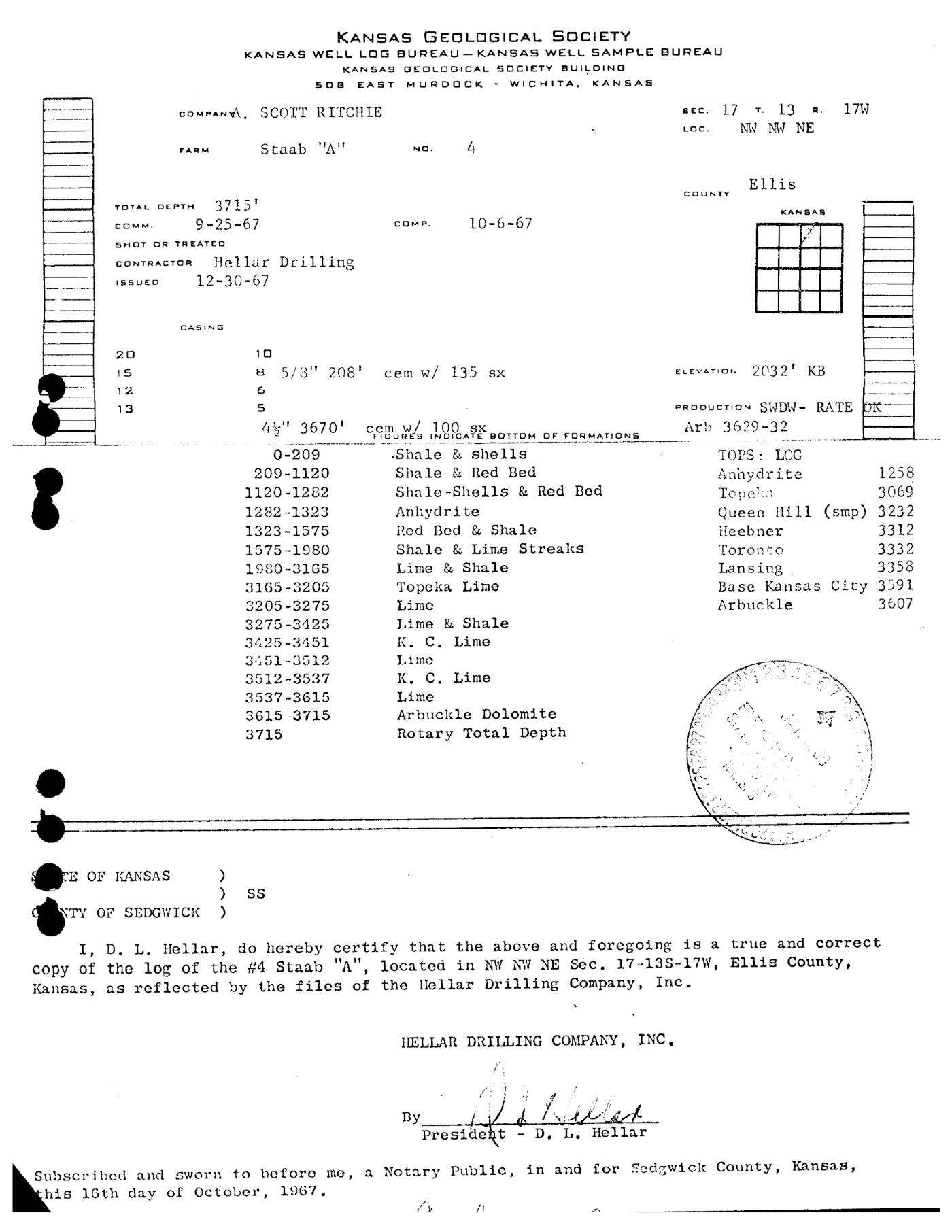 page 1
Extracted fields & KGS master-list cross-check
| Field | Value | Confidence | Page | Snippet | Cross-check |
|---|---|---|---|---|---|
| Document type | driller's log | 1.00 | p. 1 | I, D. L. Hellar, do hereby certify that the above and foregoing is a true and correct copy of the log | |
| API number | 15-051-20129 snippet not found in OCR text | 0.70 | p. 1 | Document 15-051-20129_DL: 1 page(s) follow. | match KGS: 15-051-20129 |
| Lease | Staab "A" | 1.00 | p. 1 | FARM Staab "A" NO. 4 | match KGS: STAAB 'A' |
| Well no. | 4 | 1.00 | p. 1 | FARM Staab "A" NO. 4 | match KGS: 4 |
| Operator | Scott Ritchie | 1.00 | p. 1 | COMPANY. SCOTT RITCHIE | match KGS: A. Scott Ritchie / Ritchie Exploration, Inc. |
| County | Ellis | 1.00 | p. 1 | COUNTY Ellis | match KGS: Ellis |
| Location | NW NW NE Sec. 17-13S-17W | 1.00 | p. 1 | #4 Staab "A", located in NW NW NE Sec. 17-13S-17W, Ellis County, Kansas | match KGS: 17-13S-17W |
| Section | 17 (as written: NW NW NE Sec. 17-13S-17W) | 1.00 | p. 1 | #4 Staab "A", located in NW NW NE Sec. 17-13S-17W, Ellis County, Kansas | |
| Township | 13S (as written: NW NW NE Sec. 17-13S-17W) | 1.00 | p. 1 | #4 Staab "A", located in NW NW NE Sec. 17-13S-17W, Ellis County, Kansas | |
| Range | 17W (as written: NW NW NE Sec. 17-13S-17W) | 1.00 | p. 1 | #4 Staab "A", located in NW NW NE Sec. 17-13S-17W, Ellis County, Kansas | |
| Spud date | p. 1 | missing extracted KGS: 25-SEP-1967 | |||
| Completion date | 1967-10-06 (as written: 10-6-67) | 1.00 | p. 1 | COMP. 10-6-67 | match KGS: 06-OCT-1967 |
| Plug date | p. 1 | missing extracted | |||
| Elevation KB (ft) | 2032.0 (as written: 2032') | 1.00 | p. 1 | ELEVATION 2032' KB | match KGS: 2032 KB |
| Elevation DF (ft) | p. 1 | ||||
| Elevation ground (ft) | p. 1 | ||||
| Elevation, no reference (ft) | p. 1 | ||||
| Total depth (ft) | 3715.0 (as written: 3715') | 1.00 | p. 1 | TOTAL DEPTH 3715' | match KGS: 3716 |
| Plugging | p. 1 |
Casing
| Size (in) | Depth (ft) | Cement (sx) | Purpose | Page | Snippet |
|---|---|---|---|---|---|
| 8.625 1.00 | 208.0 1.00 | 135.0 1.00 | p. 1 | 8 5/8" 208' cem w/ 135 sx | |
| 4.75 0.90 | 3670.0 0.90 | 100.0 0.90 | p. 1 | 4 3/4" 3670' cem w/ 100 sx |
Perforations
None extracted.
Formation tops
| Formation | Depth (ft) | Page | Snippet |
|---|---|---|---|
| Anhydrite 1.00 | 1258.0 1.00 | p. 1 | Anhydrite 1258 |
| Topeka 1.00 | 3069.0 1.00 | p. 1 | Topeka 3069 |
| Queen Hill (smp) 1.00 | 3232.0 1.00 | p. 1 | Queen Hill (smp) 3232 |
| Heebner 1.00 | 3312.0 1.00 | p. 1 | Heebner 3312 |
| Toronto 1.00 | 3332.0 1.00 | p. 1 | Toronto 3332 |
| Lansing 1.00 | 3358.0 1.00 | p. 1 | Lansing 3358 |
| Base Kansas City 1.00 | 3591.0 1.00 | p. 1 | Base Kansas City 3591 |
| Arbuckle 1.00 | 3607.0 1.00 | p. 1 | Arbuckle 3607 |
Tests (DST / IP)
None extracted.
QC flags
| Severity | Rule | Field | Message | Expert review |
|---|---|---|---|---|
| warning | SNIPPET_UNVERIFIED | api_number | api_number: cited snippet not found on page 1 | yes |