
H. Rader No. 2. 2 15-009-14874 · Barton County needs expert review
Document 15-009-14874_ACO · 1 page(s) · read with option layout · source scan (KGS).
Click a row to highlight where it was read on the scan. Read-only (Phase 1).
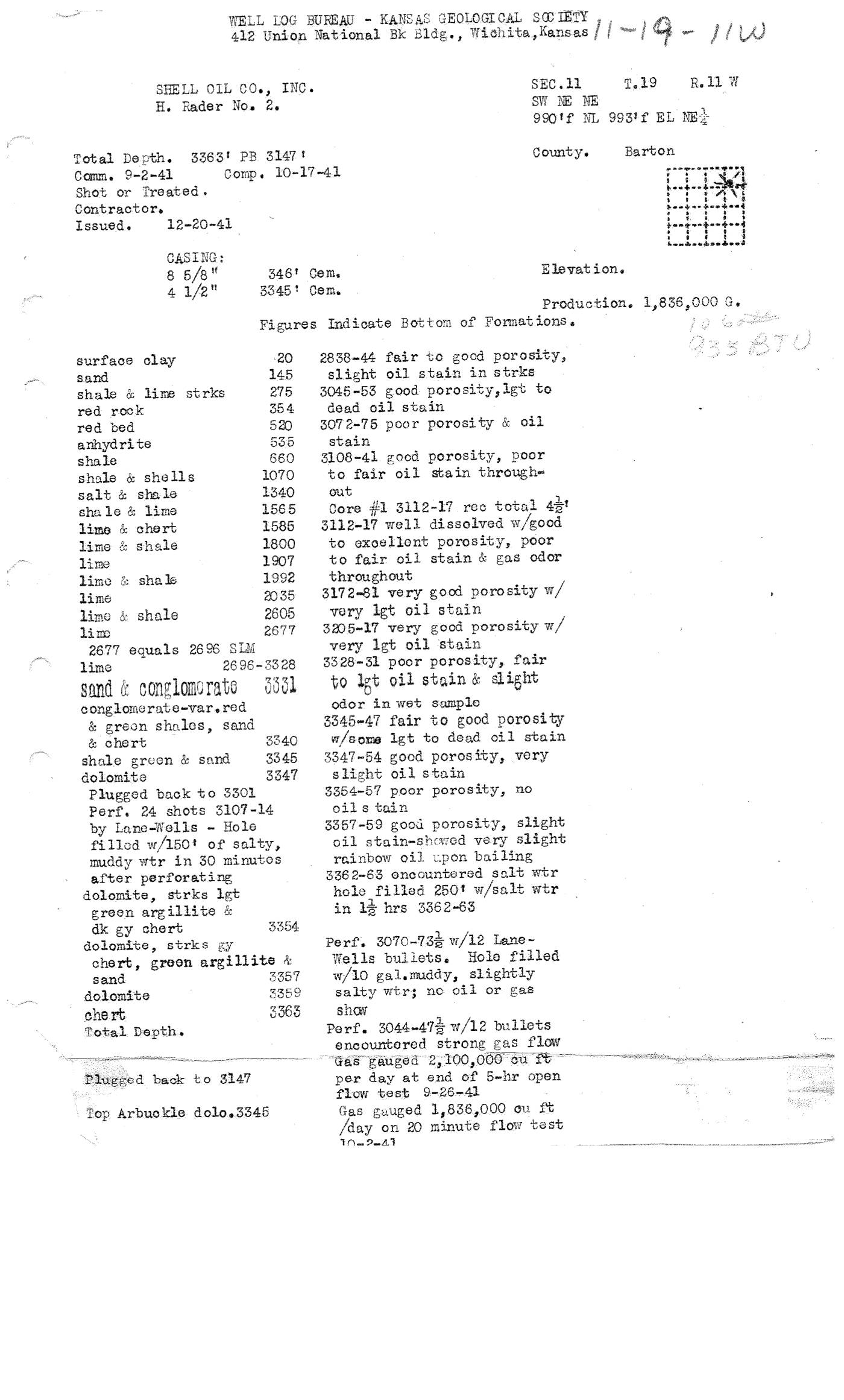 page 1
Extracted fields & KGS master-list cross-check
| Field | Value | Confidence | Page | Snippet | Cross-check |
|---|---|---|---|---|---|
| Document type | well completion form | 0.95 | p. 1 | WELL LOG BUREAU - KANSAS GEOLOGICAL SOCIETY | |
| API number | 15-009-14874 snippet not found in OCR text | 0.69 | p. 1 | Document 15-009-14874_ACO | match KGS: 15-009-14874 |
| Lease | H. Rader No. 2. | 0.97 | p. 1 | SHELL OIL CO., INC. H. Rader No. 2. | match KGS: H. Rader |
| Well no. | 2 | 0.97 | p. 1 | H. Rader No. 2. | match KGS: 2 |
| Operator | SHELL OIL CO., INC. | 0.97 | p. 1 | SHELL OIL CO., INC. | match KGS: SHELL OIL CO |
| County | Barton | 0.98 | p. 1 | County. Barton | match KGS: Barton |
| Location | SW NE NE 990' f NL 993' f EL NE 1 Sec. 11 T.19 R.11W | 0.95 | p. 1 | SEC.11 T.19 R. 11 W SW NE NE 990 'f NL 993'f EL NE | match KGS: 11-19S-11W |
| Section | 11 (as written: SW NE NE 990' f NL 993' f EL NE 1 Sec. 11 T.19 R.11W) | 0.95 | p. 1 | SEC.11 T.19 R. 11 W SW NE NE 990 'f NL 993'f EL NE | |
| Township | 19S (as written: SW NE NE 990' f NL 993' f EL NE 1 Sec. 11 T.19 R.11W) | 0.95 | p. 1 | SEC.11 T.19 R. 11 W SW NE NE 990 'f NL 993'f EL NE | |
| Range | 11W (as written: SW NE NE 990' f NL 993' f EL NE 1 Sec. 11 T.19 R.11W) | 0.95 | p. 1 | SEC.11 T.19 R. 11 W SW NE NE 990 'f NL 993'f EL NE | |
| Spud date | 1941-09-02 (as written: 9-2-41) | 0.97 | p. 1 | Comm. 9-2-41 | match KGS: 02-SEP-1941 |
| Completion date | 1941-10-17 (as written: 10-17-41) | 0.97 | p. 1 | Comp. 10-17-41 | mismatch KGS: 18-SEP-1941 |
| Plug date | p. 1 | missing extracted KGS: 11-SEP-1956 | |||
| Elevation KB (ft) | p. 1 | ||||
| Elevation DF (ft) | p. 1 | ||||
| Elevation ground (ft) | p. 1 | ||||
| Elevation, no reference (ft) | p. 1 | missing extracted KGS: 1764 DF | |||
| Total depth (ft) | 3363.0 (as written: 3363') | 0.98 | p. 1 | Total Depth. 3363' PB 3147 | match KGS: 3363 |
| Plugging | Plugged back to 3147 | 0.95 | p. 1 | Plugged back to 3147 |
Casing
| Size (in) | Depth (ft) | Cement (sx) | Purpose | Page | Snippet |
|---|---|---|---|---|---|
| 8.625 0.98 | 346.0 0.98 | 346.0 0.98 | p. 1 | CASING : 8 5/8" 346' Cem. | |
| 4.5 0.98 | 3345.0 0.98 | 3345.0 0.98 | p. 1 | 4 1/2" 3345' Cem. |
Perforations
| Top (ft) | Bottom (ft) | Formation | Page | Snippet |
|---|---|---|---|---|
| 3107.0 0.95 | 3114.0 0.95 | p. 1 | Perf. 24 shots 3107-14 | |
| 3070.0 0.95 | 736.0 0.70 | p. 1 | Perf. 3070-736 w/12 Lane- | |
| 3044.0 0.95 | 474.0 0.70 | p. 1 | Perf. 3044-474 w/12 bullets |
Formation tops
| Formation | Depth (ft) | Page | Snippet |
|---|---|---|---|
| surface clay 0.98 | 20.0 0.98 | p. 1 | surface clay |
| sand 0.98 | 145.0 0.98 | p. 1 | sand |
| shale & lime strks 0.98 | 275.0 0.98 | p. 1 | shale & lime strks |
| red rock 0.98 | 354.0 0.98 | p. 1 | red rock |
| red bed 0.98 | 520.0 0.98 | p. 1 | red bed |
| anhydrite 0.98 | 535.0 0.98 | p. 1 | anhydrite |
| shale 0.98 | 660.0 0.98 | p. 1 | shale |
| shale & shells 0.98 | 1070.0 0.98 | p. 1 | shale & shells |
| salt & shale 0.98 | 1340.0 0.98 | p. 1 | salt & sha le |
| shale & lime 0.98 | 1565.0 0.98 | p. 1 | sha le & lime |
| lime & chert 0.98 | 1585.0 0.98 | p. 1 | lime & chert |
| lime & shale 0.98 | 1800.0 0.98 | p. 1 | lime & shale |
| lime 0.98 | 1907.0 0.98 | p. 1 | lime |
| lime & shale 0.98 | 1992.0 0.98 | p. 1 | limo & sha le |
| lime 0.98 | 2035.0 0.98 | p. 1 | lime |
| lime & shale 0.98 | 2605.0 0.98 | p. 1 | limo & shale |
| lime 0.98 | 2677.0 0.98 | p. 1 | limo |
| lime 0.98 | 2696.0 0.98 | p. 1 | lime 2696-3328 |
| sand & conglomerate 0.98 | 3331.0 0.98 | p. 1 | sand & conglomorate |
| & chert 0.98 | 3340.0 0.98 | p. 1 | & chert |
| shale green & sand 0.98 | 3345.0 0.98 | p. 1 | shale green & sand |
| dolomite 0.98 | 3347.0 0.98 | p. 1 | dolomite |
| dk gy chert 0.98 | 3354.0 0.98 | p. 1 | dk gy chert |
| sand 0.98 | 3357.0 0.98 | p. 1 | sand |
| dolomite 0.98 | 3359.0 0.98 | p. 1 | dolomite |
| chert 0.98 | 3363.0 0.98 | p. 1 | che rt |
Tests (DST / IP)
| Kind | Top (ft) | Bottom (ft) | Result | Page | Snippet |
|---|---|---|---|---|---|
| open flow test 0.97 | Gas gauged 2,100,000 cu ft per day at end of 5-hr open flow test 9-26-41 0.97 | p. 1 | open flow test 9-26-41 | ||
| flow test 0.97 | Gas gauged 1,836,000 cu ft /day on 20 minute flow test 10.2-41 0.97 | p. 1 | flow test 10.2-41 |
QC flags
| Severity | Rule | Field | Message | Expert review |
|---|---|---|---|---|
| error | PERF_INVERTED | perforations[1] | Perforation top 3070 ft is below bottom 736 ft | yes |
| error | PERF_INVERTED | perforations[2] | Perforation top 3044 ft is below bottom 474 ft | yes |
| warning | SNIPPET_UNVERIFIED | api_number | api_number: cited snippet not found on page 1 | yes |